
Size of this PNG preview of this SVG file:
800 × 406 pixels. Other resolutions:
320 × 162 pixels |
640 × 325 pixels |
1,024 × 520 pixels |
1,280 × 650 pixels |
2,560 × 1,300 pixels |
2,754 × 1,398 pixels.
Original file (SVG file, nominally 2,754 × 1,398 pixels, file size: 1.05 MB)
| This is a file from the
Wikimedia Commons. Information from its
description page there is shown below. Commons is a freely licensed media file repository. You can help. |
Summary
| Description |
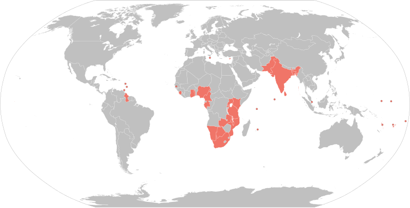
English: States within the
Commonwealth of Nations that are Republics shaded in red. A Robinson projection map of the world. |
| Date | |
| Source | Based on File:BlankMap-World6.svg (previous revisions based on File:World Map Blank.svg) |
| Author | Rcsprinter123 |
| Other versions |
See also
 |
Licensing
I, the copyright holder of this work, hereby publish it under the following license:
This file is licensed under the
Creative Commons
Attribution 3.0 Unported license.
- You are free:
- to share – to copy, distribute and transmit the work
- to remix – to adapt the work
- Under the following conditions:
- attribution – You must give appropriate credit, provide a link to the license, and indicate if changes were made. You may do so in any reasonable manner, but not in any way that suggests the licensor endorses you or your use.
File history
Click on a date/time to view the file as it appeared at that time.
| Date/Time | Thumbnail | Dimensions | User | Comment | |
|---|---|---|---|---|---|
| current | 22:08, 18 July 2022 |
| 2,754 × 1,398 (1.05 MB) | M.Bitton | Added Gabon and Togo, per request |
| 03:00, 21 December 2021 |
 | 2,754 × 1,398 (1.05 MB) | Floogan | Reverted to version as of 02:51, 21 December 2021 (UTC) | |
| 02:53, 21 December 2021 |
 | 863 × 443 (1.59 MB) | Floogan | Reverted to version as of 22:32, 10 February 2018 (UTC) | |
| 02:51, 21 December 2021 |
 | 2,754 × 1,398 (1.05 MB) | Floogan | adding maldives and barbados | |
| 22:32, 10 February 2018 |
 | 863 × 443 (1.59 MB) | DrKay | remove Northern Cyprus add Gambia | |
| 14:33, 25 November 2016 |
 | 863 × 443 (1.59 MB) | Maproom | Maldives from orange to grey, they left the Commonwealth in October 2016 | |
| 04:14, 27 February 2016 |
 | 863 × 443 (1.59 MB) | Jolly Janner | Adding Tanzania per article | |
| 21:16, 29 July 2015 |
 | 863 × 443 (1.55 MB) | MellonDor | Now using BlankMap-World6.svg as the template and added some missing republics. | |
| 11:55, 11 April 2015 |
 | 2,753 × 1,538 (2.17 MB) | Rcsprinter123 | User created page with UploadWizard |
File usage
The following pages on the English Wikipedia use this file (pages on other projects are not listed):
Global file usage
The following other wikis use this file:
- Usage on fr.wikipedia.org
- Usage on fr.wiktionary.org
- Usage on sq.wikipedia.org
- Usage on te.wikipedia.org
- Usage on tr.wikipedia.org
Metadata
Size of this PNG preview of this SVG file:
800 × 406 pixels. Other resolutions:
320 × 162 pixels |
640 × 325 pixels |
1,024 × 520 pixels |
1,280 × 650 pixels |
2,560 × 1,300 pixels |
2,754 × 1,398 pixels.
Original file (SVG file, nominally 2,754 × 1,398 pixels, file size: 1.05 MB)
| This is a file from the
Wikimedia Commons. Information from its
description page there is shown below. Commons is a freely licensed media file repository. You can help. |
Summary
| Description |
English: States within the
Commonwealth of Nations that are Republics shaded in red. A Robinson projection map of the world. |
| Date | |
| Source | Based on File:BlankMap-World6.svg (previous revisions based on File:World Map Blank.svg) |
| Author | Rcsprinter123 |
| Other versions |
See also
|
Licensing
I, the copyright holder of this work, hereby publish it under the following license:
This file is licensed under the
Creative Commons
Attribution 3.0 Unported license.
- You are free:
- to share – to copy, distribute and transmit the work
- to remix – to adapt the work
- Under the following conditions:
- attribution – You must give appropriate credit, provide a link to the license, and indicate if changes were made. You may do so in any reasonable manner, but not in any way that suggests the licensor endorses you or your use.
File history
Click on a date/time to view the file as it appeared at that time.
| Date/Time | Thumbnail | Dimensions | User | Comment | |
|---|---|---|---|---|---|
| current | 22:08, 18 July 2022 |
| 2,754 × 1,398 (1.05 MB) | M.Bitton | Added Gabon and Togo, per request |
| 03:00, 21 December 2021 |
| 2,754 × 1,398 (1.05 MB) | Floogan | Reverted to version as of 02:51, 21 December 2021 (UTC) | |
| 02:53, 21 December 2021 |
| 863 × 443 (1.59 MB) | Floogan | Reverted to version as of 22:32, 10 February 2018 (UTC) | |
| 02:51, 21 December 2021 |
| 2,754 × 1,398 (1.05 MB) | Floogan | adding maldives and barbados | |
| 22:32, 10 February 2018 |
| 863 × 443 (1.59 MB) | DrKay | remove Northern Cyprus add Gambia | |
| 14:33, 25 November 2016 |
| 863 × 443 (1.59 MB) | Maproom | Maldives from orange to grey, they left the Commonwealth in October 2016 | |
| 04:14, 27 February 2016 |
| 863 × 443 (1.59 MB) | Jolly Janner | Adding Tanzania per article | |
| 21:16, 29 July 2015 |
| 863 × 443 (1.55 MB) | MellonDor | Now using BlankMap-World6.svg as the template and added some missing republics. | |
| 11:55, 11 April 2015 |
| 2,753 × 1,538 (2.17 MB) | Rcsprinter123 | User created page with UploadWizard |
File usage
The following pages on the English Wikipedia use this file (pages on other projects are not listed):
Global file usage
The following other wikis use this file:
- Usage on fr.wikipedia.org
- Usage on fr.wiktionary.org
- Usage on sq.wikipedia.org
- Usage on te.wikipedia.org
- Usage on tr.wikipedia.org