Size of this preview:
411 × 600 pixels. Other resolutions:
164 × 240 pixels |
466 × 680 pixels.
Original file (466 × 680 pixels, file size: 104 KB, MIME type: image/png)
| This is a file from the
Wikimedia Commons. Information from its
description page there is shown below. Commons is a freely licensed media file repository. You can help. |
Summary
| Description |
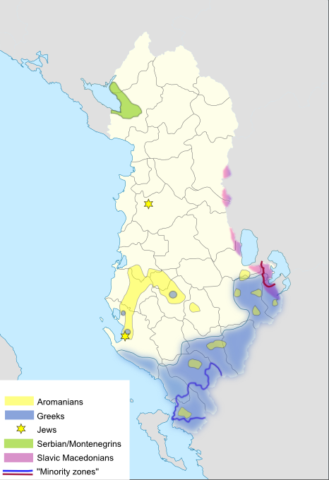
English: 1Traditional areas of ethnic and linguistic minorities living in Albania
Ελληνικά: Περιοχές που διαμένουν παραδοσιακά μη αμιγείς αλβανικοί πληθυσμοί στην Αλβανία |
| Date | 3/2/2010 |
| Source |
|
| Author | self |
| Other versions | File:Albania_minorities.svg |
Licensing
I, the copyright holder of this work, hereby publish it under the following licenses:

|
Permission is granted to copy, distribute and/or modify this document under the terms of the GNU Free Documentation License, Version 1.2 or any later version published by the Free Software Foundation; with no Invariant Sections, no Front-Cover Texts, and no Back-Cover Texts. A copy of the license is included in the section entitled GNU Free Documentation License. |
This file is licensed under the
Creative Commons Attribution ShareAlike license, versions
1.0,
2.0,
2.5,
3.0,
4.0 and any later version released by Creative Commons. You may select the version of your choice. In short: you are free to share and make derivative works of the file under the conditions that you appropriately attribute it, and that you distribute it only under a license identical to this one. Official license:
1.0,
2.0,
2.5,
3.0,
4.0
|
You may select the license of your choice.
File history
Click on a date/time to view the file as it appeared at that time.
| Date/Time | Thumbnail | Dimensions | User | Comment | |
|---|---|---|---|---|---|
| current | 03:59, 15 August 2019 |
| 466 × 680 (104 KB) | Bidgee | Reverted to version as of 08:46, 26 February 2010 (UTC) per COM:OVERWRITE |
| 08:11, 14 August 2019 |
 | 466 × 680 (108 KB) | AceDouble | Rv it is clearly based on the "Autonomous Republic of Northern Epirus" map. | |
| 08:48, 6 August 2019 |
 | 466 × 680 (121 KB) | Alexikoua | it's about traditional presence not majorities area | |
| 08:50, 26 July 2019 |
 | 466 × 680 (108 KB) | AceDouble | rv per sources given in description : http://www.muturzikin.com & links 1 & 2 | |
| 11:24, 28 April 2018 |
 | 466 × 680 (121 KB) | Alexikoua | Reverted to version as of 19:02, 21 April 2018 (UTC) | |
| 08:04, 26 April 2018 |
 | 466 × 680 (108 KB) | AceDouble | Reverted to version as of 14:44, 19 April 2018 (UTC) As alexikoua interrupts and likes to see other maps on his own desire, i will change this map until he will stop messing around. | |
| 19:02, 21 April 2018 |
 | 466 × 680 (121 KB) | Khirurg | POV-push | |
| 14:44, 19 April 2018 |
 | 466 × 680 (108 KB) | AceDouble | per given source: http://www.muturzikin.com/carteseurope/europe.htm | |
| 13:08, 1 January 2018 |
 | 466 × 680 (121 KB) | MacedonianBoy | Reverted to version as of 23:27, 21 April 2013 (UTC) | |
| 21:10, 10 September 2015 |
 | 466 × 680 (104 KB) | Alexikoua | precise name |
File usage
The following pages on the English Wikipedia use this file (pages on other projects are not listed):
Global file usage
The following other wikis use this file:
- Usage on ami.wikipedia.org
- Usage on an.wikipedia.org
- Usage on ar.wikipedia.org
- Usage on arz.wikipedia.org
- Usage on az.wikipedia.org
- Usage on ba.wikipedia.org
- Usage on ca.wikipedia.org
- Usage on cs.wikipedia.org
- Usage on cy.wikipedia.org
- Usage on de.wikipedia.org
- Usage on el.wikipedia.org
- Usage on eo.wikipedia.org
- Usage on fr.wikipedia.org
- Usage on hr.wikipedia.org
- Usage on mk.wikipedia.org
- Usage on myv.wikipedia.org
- Usage on pl.wikipedia.org
- Usage on pt.wikipedia.org
- Usage on ro.wikipedia.org
- Usage on ru.wikipedia.org
- Usage on sk.wikipedia.org
- Usage on sr.wikipedia.org
- Usage on te.wikipedia.org
- Usage on tr.wikipedia.org
- Usage on uk.wikipedia.org
- Usage on zh.wikipedia.org
Size of this preview:
411 × 600 pixels. Other resolutions:
164 × 240 pixels |
466 × 680 pixels.
Original file (466 × 680 pixels, file size: 104 KB, MIME type: image/png)
| This is a file from the
Wikimedia Commons. Information from its
description page there is shown below. Commons is a freely licensed media file repository. You can help. |
Summary
| Description |
English: 1Traditional areas of ethnic and linguistic minorities living in Albania
Ελληνικά: Περιοχές που διαμένουν παραδοσιακά μη αμιγείς αλβανικοί πληθυσμοί στην Αλβανία |
| Date | 3/2/2010 |
| Source |
|
| Author | self |
| Other versions | File:Albania_minorities.svg |
Licensing
I, the copyright holder of this work, hereby publish it under the following licenses:
|
|
Permission is granted to copy, distribute and/or modify this document under the terms of the GNU Free Documentation License, Version 1.2 or any later version published by the Free Software Foundation; with no Invariant Sections, no Front-Cover Texts, and no Back-Cover Texts. A copy of the license is included in the section entitled GNU Free Documentation License. |
This file is licensed under the
Creative Commons Attribution ShareAlike license, versions
1.0,
2.0,
2.5,
3.0,
4.0 and any later version released by Creative Commons. You may select the version of your choice. In short: you are free to share and make derivative works of the file under the conditions that you appropriately attribute it, and that you distribute it only under a license identical to this one. Official license:
1.0,
2.0,
2.5,
3.0,
4.0
|
You may select the license of your choice.
File history
Click on a date/time to view the file as it appeared at that time.
| Date/Time | Thumbnail | Dimensions | User | Comment | |
|---|---|---|---|---|---|
| current | 03:59, 15 August 2019 |
| 466 × 680 (104 KB) | Bidgee | Reverted to version as of 08:46, 26 February 2010 (UTC) per COM:OVERWRITE |
| 08:11, 14 August 2019 |
| 466 × 680 (108 KB) | AceDouble | Rv it is clearly based on the "Autonomous Republic of Northern Epirus" map. | |
| 08:48, 6 August 2019 |
| 466 × 680 (121 KB) | Alexikoua | it's about traditional presence not majorities area | |
| 08:50, 26 July 2019 |
| 466 × 680 (108 KB) | AceDouble | rv per sources given in description : http://www.muturzikin.com & links 1 & 2 | |
| 11:24, 28 April 2018 |
| 466 × 680 (121 KB) | Alexikoua | Reverted to version as of 19:02, 21 April 2018 (UTC) | |
| 08:04, 26 April 2018 |
| 466 × 680 (108 KB) | AceDouble | Reverted to version as of 14:44, 19 April 2018 (UTC) As alexikoua interrupts and likes to see other maps on his own desire, i will change this map until he will stop messing around. | |
| 19:02, 21 April 2018 |
| 466 × 680 (121 KB) | Khirurg | POV-push | |
| 14:44, 19 April 2018 |
| 466 × 680 (108 KB) | AceDouble | per given source: http://www.muturzikin.com/carteseurope/europe.htm | |
| 13:08, 1 January 2018 |
| 466 × 680 (121 KB) | MacedonianBoy | Reverted to version as of 23:27, 21 April 2013 (UTC) | |
| 21:10, 10 September 2015 |
| 466 × 680 (104 KB) | Alexikoua | precise name |
File usage
The following pages on the English Wikipedia use this file (pages on other projects are not listed):
Global file usage
The following other wikis use this file:
- Usage on ami.wikipedia.org
- Usage on an.wikipedia.org
- Usage on ar.wikipedia.org
- Usage on arz.wikipedia.org
- Usage on az.wikipedia.org
- Usage on ba.wikipedia.org
- Usage on ca.wikipedia.org
- Usage on cs.wikipedia.org
- Usage on cy.wikipedia.org
- Usage on de.wikipedia.org
- Usage on el.wikipedia.org
- Usage on eo.wikipedia.org
- Usage on fr.wikipedia.org
- Usage on hr.wikipedia.org
- Usage on mk.wikipedia.org
- Usage on myv.wikipedia.org
- Usage on pl.wikipedia.org
- Usage on pt.wikipedia.org
- Usage on ro.wikipedia.org
- Usage on ru.wikipedia.org
- Usage on sk.wikipedia.org
- Usage on sr.wikipedia.org
- Usage on te.wikipedia.org
- Usage on tr.wikipedia.org
- Usage on uk.wikipedia.org
- Usage on zh.wikipedia.org