
Size of this preview:
461 × 599 pixels. Other resolutions:
184 × 240 pixels |
540 × 702 pixels.
Original file (540 × 702 pixels, file size: 26 KB, MIME type: image/png)
| This is a file from the
Wikimedia Commons. Information from its
description page there is shown below. Commons is a freely licensed media file repository. You can help. |
Summary
| Description |
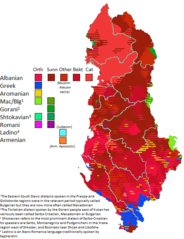
English: This map, using a wide variety of sources (available in a chart for where they apply), charts the traditional locations of notable linguistic and religious communities in Albania, around the early 20th century. Note that hatched areas imply the presence of multiple groups, but they do not imply parity-- in fact usually there is not parity. Thus this map underrepresents the demographic weight of local majorities -- such as Sunnis in Elbasan who are in a hatched area with Orthodox who they vastly outnumber. Thus in different areas, Sunni Albanians, Bektashi Albanians, Orthodox Albanians, Catholic Albanians, and Orthodox Greeks are likely underrepresented, while smaller groups (Vlachs, Sephardim, Roma) may be overrepresented where they occur. The citation chart for this map is can be found
here (currently under construction still). If you do choose to edit this file, please edit this page as well so I know which sources you used. You may also use this page to request edits to the file, by presenting a source and saying where it pertains to, below the chart. |
| Date | |
| Source | Own work |
| Author | Calthinus |
Licensing
I, the copyright holder of this work, hereby publish it under the following license:
This file is licensed under the
Creative Commons
Attribution-Share Alike 4.0 International license.
- You are free:
- to share – to copy, distribute and transmit the work
- to remix – to adapt the work
- Under the following conditions:
- attribution – You must give appropriate credit, provide a link to the license, and indicate if changes were made. You may do so in any reasonable manner, but not in any way that suggests the licensor endorses you or your use.
- share alike – If you remix, transform, or build upon the material, you must distribute your contributions under the same or compatible license as the original.
File history
Click on a date/time to view the file as it appeared at that time.
| Date/Time | Thumbnail | Dimensions | User | Comment | |
|---|---|---|---|---|---|
| current | 05:37, 5 November 2021 |
| 540 × 702 (26 KB) | User-duck | Cropped narrower using CropTool with lossless mode. |
| 22:16, 18 January 2020 |
 | 655 × 709 (70 KB) | Calthinus | let's try this again.... | |
| 21:33, 17 January 2020 |
 | 655 × 709 (71 KB) | Calthinus | Labova to mixed -- source reports village as Greek/Albanian mixed in early to mid 20th century before settlement of Vlachs (Hammond, Hemming; Kahl on Vlach settlement). Extend Greek area West of Himare munic to Grammata bay per comments by Kh/Alexikoua, that's fair enough. Per Resnjari and Khirurg, change Albanian enclaves in Vurg to dots (I can't find the cadastre map but I suppose this will do). Remove Greek patch in Moscopole per Resnjari's complaint. | |
| 03:51, 11 January 2018 |
 | 655 × 709 (67 KB) | Calthinus | fixes in Himara, Zagori, Permet. Will deal with Vurg and Moscopole soon. | |
| 16:32, 30 December 2017 |
 | 655 × 709 (67 KB) | Calthinus | I appreciate the attempt but this is not fitting the language-religion paradigm. I will fix permet once I get a moment. Thanks. | |
| 22:44, 29 December 2017 |
 | 655 × 709 (72 KB) | SilentResident | Updated map with the missing sources from Philippe Rekacewicz and George Soteriadis to eliminate potential POV issues. Now the updated map contains all scholarship about the Greek population inhabiting these areas. The missing sources that have been a... | |
| 00:04, 23 December 2017 |
 | 655 × 709 (67 KB) | Calthinus | oops uploaded wrong one | |
| 00:00, 23 December 2017 |
 | 655 × 709 (67 KB) | Calthinus | Apparently there are no Slavic Muslims in Tarnovo, as per Ylli + Steinke. Also some fixes elsewhere | |
| 05:50, 20 December 2017 |
 | 655 × 709 (67 KB) | Calthinus | quick fix | |
| 05:19, 20 December 2017 |
 | 655 × 709 (67 KB) | Calthinus | fixes for a couple towns |
File usage
The following pages on the English Wikipedia use this file (pages on other projects are not listed):
Global file usage
The following other wikis use this file:
- Usage on ar.wikipedia.org
- Usage on az.wikipedia.org
- Usage on bn.wikipedia.org
- Usage on cs.wikipedia.org
- Usage on de.wikipedia.org
- Usage on el.wikipedia.org
- Usage on fy.wikipedia.org
- Usage on hu.wikipedia.org
- Usage on it.wikipedia.org
- Usage on ko.wikipedia.org
- Usage on lv.wikipedia.org
- Usage on mk.wikipedia.org
- Usage on ro.wikipedia.org
- Usage on ru.wikipedia.org
- Usage on te.wikipedia.org
- Usage on tr.wikipedia.org
- Usage on uk.wikipedia.org
Metadata
Size of this preview:
461 × 599 pixels. Other resolutions:
184 × 240 pixels |
540 × 702 pixels.
Original file (540 × 702 pixels, file size: 26 KB, MIME type: image/png)
| This is a file from the
Wikimedia Commons. Information from its
description page there is shown below. Commons is a freely licensed media file repository. You can help. |
Summary
| Description |
English: This map, using a wide variety of sources (available in a chart for where they apply), charts the traditional locations of notable linguistic and religious communities in Albania, around the early 20th century. Note that hatched areas imply the presence of multiple groups, but they do not imply parity-- in fact usually there is not parity. Thus this map underrepresents the demographic weight of local majorities -- such as Sunnis in Elbasan who are in a hatched area with Orthodox who they vastly outnumber. Thus in different areas, Sunni Albanians, Bektashi Albanians, Orthodox Albanians, Catholic Albanians, and Orthodox Greeks are likely underrepresented, while smaller groups (Vlachs, Sephardim, Roma) may be overrepresented where they occur. The citation chart for this map is can be found
here (currently under construction still). If you do choose to edit this file, please edit this page as well so I know which sources you used. You may also use this page to request edits to the file, by presenting a source and saying where it pertains to, below the chart. |
| Date | |
| Source | Own work |
| Author | Calthinus |
Licensing
I, the copyright holder of this work, hereby publish it under the following license:
This file is licensed under the
Creative Commons
Attribution-Share Alike 4.0 International license.
- You are free:
- to share – to copy, distribute and transmit the work
- to remix – to adapt the work
- Under the following conditions:
- attribution – You must give appropriate credit, provide a link to the license, and indicate if changes were made. You may do so in any reasonable manner, but not in any way that suggests the licensor endorses you or your use.
- share alike – If you remix, transform, or build upon the material, you must distribute your contributions under the same or compatible license as the original.
File history
Click on a date/time to view the file as it appeared at that time.
| Date/Time | Thumbnail | Dimensions | User | Comment | |
|---|---|---|---|---|---|
| current | 05:37, 5 November 2021 |
| 540 × 702 (26 KB) | User-duck | Cropped narrower using CropTool with lossless mode. |
| 22:16, 18 January 2020 |
| 655 × 709 (70 KB) | Calthinus | let's try this again.... | |
| 21:33, 17 January 2020 |
| 655 × 709 (71 KB) | Calthinus | Labova to mixed -- source reports village as Greek/Albanian mixed in early to mid 20th century before settlement of Vlachs (Hammond, Hemming; Kahl on Vlach settlement). Extend Greek area West of Himare munic to Grammata bay per comments by Kh/Alexikoua, that's fair enough. Per Resnjari and Khirurg, change Albanian enclaves in Vurg to dots (I can't find the cadastre map but I suppose this will do). Remove Greek patch in Moscopole per Resnjari's complaint. | |
| 03:51, 11 January 2018 |
| 655 × 709 (67 KB) | Calthinus | fixes in Himara, Zagori, Permet. Will deal with Vurg and Moscopole soon. | |
| 16:32, 30 December 2017 |
| 655 × 709 (67 KB) | Calthinus | I appreciate the attempt but this is not fitting the language-religion paradigm. I will fix permet once I get a moment. Thanks. | |
| 22:44, 29 December 2017 |
| 655 × 709 (72 KB) | SilentResident | Updated map with the missing sources from Philippe Rekacewicz and George Soteriadis to eliminate potential POV issues. Now the updated map contains all scholarship about the Greek population inhabiting these areas. The missing sources that have been a... | |
| 00:04, 23 December 2017 |
| 655 × 709 (67 KB) | Calthinus | oops uploaded wrong one | |
| 00:00, 23 December 2017 |
| 655 × 709 (67 KB) | Calthinus | Apparently there are no Slavic Muslims in Tarnovo, as per Ylli + Steinke. Also some fixes elsewhere | |
| 05:50, 20 December 2017 |
| 655 × 709 (67 KB) | Calthinus | quick fix | |
| 05:19, 20 December 2017 |
| 655 × 709 (67 KB) | Calthinus | fixes for a couple towns |
File usage
The following pages on the English Wikipedia use this file (pages on other projects are not listed):
Global file usage
The following other wikis use this file:
- Usage on ar.wikipedia.org
- Usage on az.wikipedia.org
- Usage on bn.wikipedia.org
- Usage on cs.wikipedia.org
- Usage on de.wikipedia.org
- Usage on el.wikipedia.org
- Usage on fy.wikipedia.org
- Usage on hu.wikipedia.org
- Usage on it.wikipedia.org
- Usage on ko.wikipedia.org
- Usage on lv.wikipedia.org
- Usage on mk.wikipedia.org
- Usage on ro.wikipedia.org
- Usage on ru.wikipedia.org
- Usage on te.wikipedia.org
- Usage on tr.wikipedia.org
- Usage on uk.wikipedia.org