Dudince | |
|---|---|
Town | |
 | |
 Coat of arms | |
 Dudince Location of Dudince in the
Banská Bystrica Region  Dudince Location of Dudince in Slovakia | |
| Coordinates: 48°10′00″N 18°52′58″E / 48.16667°N 18.88278°E | |
| Country | |
| Region | Banská Bystrica |
| District | Krupina |
| Founded | 1284 |
| Government | |
| • Mayor | Dušan Strieborný |
| Area | |
| • Total | 6.85 km2 (2.64 sq mi) |
| (2022) | |
| Elevation | 140 m (460 ft) |
| Population | |
| • Total | 1,369 |
| • Density | 200/km2 (520/sq mi) |
| Time zone | UTC+1 ( CET) |
| • Summer ( DST) | UTC+2 ( CEST) |
| Postal code | 962 71 |
| Area code | +421-45 |
| Car plate | KA |
| Website | dudince-mesto.sk |
Dudince (before 1927 Ďudince, Hungarian: Gyűgy, rarely German: Dudintze) is a spa town in southern Slovakia. It is the smallest town in Slovakia with only a population of around 1,400. It is known for its mineral water, hot springs and destination spas. It's located near the edge of the Banská Bystrica Region of Slovakia.
Geography
It is located in the foothills of the Krupina Plain (inner western Carpathian Mountains) in the valley of the Štiavnica river, around 27 km south-west from Krupina and 15 km north from Šahy. Besides the main settlement, there is a formerly independent village, Merovce (annexed in 1960).
The town lies in the Stredoslovenska wine region and is surrounded by vineyards. Travertine piles and "Roman" spa (see image gallery) can also be found.
Climate
| Climate data for Dudince (1991−2020) | |||||||||||||
|---|---|---|---|---|---|---|---|---|---|---|---|---|---|
| Month | Jan | Feb | Mar | Apr | May | Jun | Jul | Aug | Sep | Oct | Nov | Dec | Year |
| Record high °C (°F) | 15.1 (59.2) |
18.8 (65.8) |
23.8 (74.8) |
31.5 (88.7) |
32.9 (91.2) |
37.0 (98.6) |
40.2 (104.4) |
38.9 (102.0) |
34.5 (94.1) |
29.0 (84.2) |
22.4 (72.3) |
15.4 (59.7) |
40.2 (104.4) |
| Mean daily maximum °C (°F) | 2.7 (36.9) |
5.9 (42.6) |
11.4 (52.5) |
18.1 (64.6) |
22.8 (73.0) |
26.3 (79.3) |
28.6 (83.5) |
28.5 (83.3) |
22.7 (72.9) |
16.2 (61.2) |
9.3 (48.7) |
3.3 (37.9) |
16.3 (61.3) |
| Daily mean °C (°F) | −1.2 (29.8) |
0.7 (33.3) |
5.0 (41.0) |
11.0 (51.8) |
15.8 (60.4) |
19.5 (67.1) |
21.2 (70.2) |
20.6 (69.1) |
15.2 (59.4) |
9.8 (49.6) |
5.1 (41.2) |
0.0 (32.0) |
10.2 (50.4) |
| Mean daily minimum °C (°F) | −4.8 (23.4) |
−3.9 (25.0) |
0.4 (32.7) |
3.9 (39.0) |
8.7 (47.7) |
12.3 (54.1) |
13.9 (57.0) |
13.8 (56.8) |
9.5 (49.1) |
5.0 (41.0) |
1.5 (34.7) |
−3.3 (26.1) |
4.7 (40.5) |
| Record low °C (°F) | −30.3 (−22.5) |
−21.2 (−6.2) |
−17.1 (1.2) |
−7.8 (18.0) |
−2.8 (27.0) |
1.1 (34.0) |
4.3 (39.7) |
4.0 (39.2) |
−1.3 (29.7) |
−10.5 (13.1) |
−14.0 (6.8) |
−26.1 (−15.0) |
−30.3 (−22.5) |
| Average precipitation mm (inches) | 39.0 (1.54) |
34.1 (1.34) |
35.6 (1.40) |
37.8 (1.49) |
66.5 (2.62) |
71.1 (2.80) |
75.7 (2.98) |
64.1 (2.52) |
54.8 (2.16) |
48.5 (1.91) |
49.4 (1.94) |
42.5 (1.67) |
619.1 (24.37) |
| Average precipitation days (≥ 1.0 mm) | 7.1 | 6.9 | 6.7 | 6.1 | 8.7 | 8.0 | 8.3 | 6.8 | 6.8 | 7.1 | 8.3 | 7.4 | 88.2 |
| Average snowy days | 8.6 | 6.6 | 3.4 | 0.7 | 0.0 | 0.0 | 0.0 | 0.0 | 0.0 | 0.2 | 2.9 | 6.4 | 28.8 |
| Average relative humidity (%) | 85.0 | 79.5 | 72.2 | 65.9 | 69.0 | 69.8 | 67.8 | 69.9 | 75.8 | 81.3 | 84.5 | 86.5 | 75.6 |
| Mean monthly sunshine hours | 61.3 | 96.3 | 157.0 | 215.7 | 252.0 | 267.9 | 281.1 | 271.6 | 193.0 | 139.7 | 72.8 | 49.4 | 2,057.8 |
| Source: NOAA [3] | |||||||||||||
History
Archaeological discoveries show that the town was inhabited in the Neolithic era. The first written acknowledgement dates back to 1284 as Dyud. The oldest mention of hot springs was in 1551, but there is strong evidence that the Romas knew of the thermal pools over 2000 years ago.
It was the venue for the 2013 European Race Walking Cup.
Demographics
According to the 2001 census, the town had 1,500 inhabitants. 95.67% of inhabitants were Slovaks, 3.53% Hungarians and 0.20% Roma. [4] The religious make-up was 55.67% Roman Catholics, 28.93% Lutherans and 11.27% people with no religious affiliation. [4]
Sister city
Dudince is a twin town of Kent, Ohio, in the United States.
See also
References
- ^ Statistical Office of the Slovak Republic (www.statistics.sk). "Hustota obyvateľstva - obce". www.statistics.sk. Retrieved 2024-02-08.
- ^ Statistical Office of the Slovak Republic (www.statistics.sk). "Počet obyvateľov podľa pohlavia - obce (ročne)". www.statistics.sk. Retrieved 2024-02-08.
- ^ "Dudince Climate Normals 1991–2020". World Meteorological Organization Climatological Standard Normals (1991–2020). National Oceanic and Atmospheric Administration. Archived from the original on 14 August 2023. Retrieved 14 August 2023.
- ^ a b "Municipal Statistics". Statistical Office of the Slovak republic. Archived from the original on 2007-12-17. Retrieved 2007-12-26.
Genealogical resources
The records for genealogical research are available at the state archive, Statny Archiv in Banska Bystrica, Nitra, Slovakia.
- Roman Catholic church records (births/marriages/deaths): 1784-1893 (parish B)
- Lutheran church records (births/marriages/deaths): 1783-1929 (parish B)
Photos
-
 Thermal water source
 -
 Thermal water source
 -
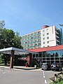 Hotel Rubin
 -
 Hotel Rubin
 -
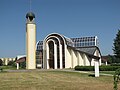 Parish Church of Our Lady Queen of Peace
 -
 Parish Church of Our Lady Queen of Peace
 -
 Park detail
,_gy%C3%B3gyv%C3%ADz_forr%C3%A1sk%C3%BAp.JPG)
,_gy%C3%B3gyv%C3%ADz_iv%C3%B3k%C3%BAt_02.jpg)
,_Hotel_Rubin.JPG)
,_parkr%C3%A9szlet_a_sz%C3%A1llod%C3%A1val.JPG)
,_Farsk%C3%BD_kostol_Panny_M%C3%A1rie_Kr%C3%A1%C4%BEovnej_pokoja.jpg)
,_Farsk%C3%BD_kostol_Panny_M%C3%A1rie_Kr%C3%A1%C4%BEovnej_pokoja_03.jpg)
,_parkr%C3%A9szlet.jpg)
External links
-
 Media related to
Dudince at Wikimedia Commons
Media related to
Dudince at Wikimedia Commons -
Official website

- Spa Dudince
- Photo gallery from Dudince spa
- Dudince and its spa resorts
- Surnames of living people in Dudince
| International | |
|---|---|
| National | |
|
| This Banská Bystrica Region geography article is a stub. You can help Wikipedia by expanding it. |
Dudince | |
|---|---|
Town | |
|
| |
|
Coat of arms | |
Dudince Location of Dudince in the
Banská Bystrica Region Dudince Location of Dudince in Slovakia | |
| Coordinates: 48°10′00″N 18°52′58″E / 48.16667°N 18.88278°E | |
| Country | |
| Region | Banská Bystrica |
| District | Krupina |
| Founded | 1284 |
| Government | |
| • Mayor | Dušan Strieborný |
| Area | |
| • Total | 6.85 km2 (2.64 sq mi) |
| (2022) | |
| Elevation | 140 m (460 ft) |
| Population | |
| • Total | 1,369 |
| • Density | 200/km2 (520/sq mi) |
| Time zone | UTC+1 ( CET) |
| • Summer ( DST) | UTC+2 ( CEST) |
| Postal code | 962 71 |
| Area code | +421-45 |
| Car plate | KA |
| Website | dudince-mesto.sk |
Dudince (before 1927 Ďudince, Hungarian: Gyűgy, rarely German: Dudintze) is a spa town in southern Slovakia. It is the smallest town in Slovakia with only a population of around 1,400. It is known for its mineral water, hot springs and destination spas. It's located near the edge of the Banská Bystrica Region of Slovakia.
Geography
It is located in the foothills of the Krupina Plain (inner western Carpathian Mountains) in the valley of the Štiavnica river, around 27 km south-west from Krupina and 15 km north from Šahy. Besides the main settlement, there is a formerly independent village, Merovce (annexed in 1960).
The town lies in the Stredoslovenska wine region and is surrounded by vineyards. Travertine piles and "Roman" spa (see image gallery) can also be found.
Climate
| Climate data for Dudince (1991−2020) | |||||||||||||
|---|---|---|---|---|---|---|---|---|---|---|---|---|---|
| Month | Jan | Feb | Mar | Apr | May | Jun | Jul | Aug | Sep | Oct | Nov | Dec | Year |
| Record high °C (°F) | 15.1 (59.2) |
18.8 (65.8) |
23.8 (74.8) |
31.5 (88.7) |
32.9 (91.2) |
37.0 (98.6) |
40.2 (104.4) |
38.9 (102.0) |
34.5 (94.1) |
29.0 (84.2) |
22.4 (72.3) |
15.4 (59.7) |
40.2 (104.4) |
| Mean daily maximum °C (°F) | 2.7 (36.9) |
5.9 (42.6) |
11.4 (52.5) |
18.1 (64.6) |
22.8 (73.0) |
26.3 (79.3) |
28.6 (83.5) |
28.5 (83.3) |
22.7 (72.9) |
16.2 (61.2) |
9.3 (48.7) |
3.3 (37.9) |
16.3 (61.3) |
| Daily mean °C (°F) | −1.2 (29.8) |
0.7 (33.3) |
5.0 (41.0) |
11.0 (51.8) |
15.8 (60.4) |
19.5 (67.1) |
21.2 (70.2) |
20.6 (69.1) |
15.2 (59.4) |
9.8 (49.6) |
5.1 (41.2) |
0.0 (32.0) |
10.2 (50.4) |
| Mean daily minimum °C (°F) | −4.8 (23.4) |
−3.9 (25.0) |
0.4 (32.7) |
3.9 (39.0) |
8.7 (47.7) |
12.3 (54.1) |
13.9 (57.0) |
13.8 (56.8) |
9.5 (49.1) |
5.0 (41.0) |
1.5 (34.7) |
−3.3 (26.1) |
4.7 (40.5) |
| Record low °C (°F) | −30.3 (−22.5) |
−21.2 (−6.2) |
−17.1 (1.2) |
−7.8 (18.0) |
−2.8 (27.0) |
1.1 (34.0) |
4.3 (39.7) |
4.0 (39.2) |
−1.3 (29.7) |
−10.5 (13.1) |
−14.0 (6.8) |
−26.1 (−15.0) |
−30.3 (−22.5) |
| Average precipitation mm (inches) | 39.0 (1.54) |
34.1 (1.34) |
35.6 (1.40) |
37.8 (1.49) |
66.5 (2.62) |
71.1 (2.80) |
75.7 (2.98) |
64.1 (2.52) |
54.8 (2.16) |
48.5 (1.91) |
49.4 (1.94) |
42.5 (1.67) |
619.1 (24.37) |
| Average precipitation days (≥ 1.0 mm) | 7.1 | 6.9 | 6.7 | 6.1 | 8.7 | 8.0 | 8.3 | 6.8 | 6.8 | 7.1 | 8.3 | 7.4 | 88.2 |
| Average snowy days | 8.6 | 6.6 | 3.4 | 0.7 | 0.0 | 0.0 | 0.0 | 0.0 | 0.0 | 0.2 | 2.9 | 6.4 | 28.8 |
| Average relative humidity (%) | 85.0 | 79.5 | 72.2 | 65.9 | 69.0 | 69.8 | 67.8 | 69.9 | 75.8 | 81.3 | 84.5 | 86.5 | 75.6 |
| Mean monthly sunshine hours | 61.3 | 96.3 | 157.0 | 215.7 | 252.0 | 267.9 | 281.1 | 271.6 | 193.0 | 139.7 | 72.8 | 49.4 | 2,057.8 |
| Source: NOAA [3] | |||||||||||||
History
Archaeological discoveries show that the town was inhabited in the Neolithic era. The first written acknowledgement dates back to 1284 as Dyud. The oldest mention of hot springs was in 1551, but there is strong evidence that the Romas knew of the thermal pools over 2000 years ago.
It was the venue for the 2013 European Race Walking Cup.
Demographics
According to the 2001 census, the town had 1,500 inhabitants. 95.67% of inhabitants were Slovaks, 3.53% Hungarians and 0.20% Roma. [4] The religious make-up was 55.67% Roman Catholics, 28.93% Lutherans and 11.27% people with no religious affiliation. [4]
Sister city
Dudince is a twin town of Kent, Ohio, in the United States.
See also
References
- ^ Statistical Office of the Slovak Republic (www.statistics.sk). "Hustota obyvateľstva - obce". www.statistics.sk. Retrieved 2024-02-08.
- ^ Statistical Office of the Slovak Republic (www.statistics.sk). "Počet obyvateľov podľa pohlavia - obce (ročne)". www.statistics.sk. Retrieved 2024-02-08.
- ^ "Dudince Climate Normals 1991–2020". World Meteorological Organization Climatological Standard Normals (1991–2020). National Oceanic and Atmospheric Administration. Archived from the original on 14 August 2023. Retrieved 14 August 2023.
- ^ a b "Municipal Statistics". Statistical Office of the Slovak republic. Archived from the original on 2007-12-17. Retrieved 2007-12-26.
Genealogical resources
The records for genealogical research are available at the state archive, Statny Archiv in Banska Bystrica, Nitra, Slovakia.
- Roman Catholic church records (births/marriages/deaths): 1784-1893 (parish B)
- Lutheran church records (births/marriages/deaths): 1783-1929 (parish B)
Photos
-
Thermal water source
-
Thermal water source
-
Hotel Rubin
-
Hotel Rubin
-
Parish Church of Our Lady Queen of Peace
-
Parish Church of Our Lady Queen of Peace
-
Park detail
External links
-
Media related to
Dudince at Wikimedia Commons
-
Official website
- Spa Dudince
- Photo gallery from Dudince spa
- Dudince and its spa resorts
- Surnames of living people in Dudince
| International | |
|---|---|
| National | |
|
| This Banská Bystrica Region geography article is a stub. You can help Wikipedia by expanding it. |