Bafatá | |
|---|---|
_(2).jpg) | |
 Bafatá Location in Guinea-Bissau  Bafatá Bafatá (Africa) | |
| Coordinates: 12°10′19″N 14°39′27″W / 12.17194°N 14.65750°W | |
| Country |
|
| Admin. Region | Bafatá Region |
| Elevation | 10 m (30 ft) |
| Population (2010) | |
| • Total | 34,760 |
Bafatá is a town in central Guinea-Bissau, known as the birthplace of Amílcar Cabral. [1] The town has a population of 22,501 (2008 est). [2] It is the capital of Bafatá Region as well as the seat of the Roman Catholic Diocese of Bafatá, which was established in March 2001 with Carlos Pedro Zilli as bishop. [3]
Bafatá is noted for its brickmaking. [4] By the 1880s it was an established trading centre for the Portuguese, including peanuts, cattle, hides, textiles, and salt. [5]
Landmarks
The town is served by Bafatá Airport, an airstrip, [6] and a regional hospital. [7] There is a hotel, the Bafatá Apartamento Imel. The restaurant Ponto de Encontro serves Portuguese cuisine. The surrounding forests are noted for their monkey and antelope populations, and Maimama Cape, owned by a Cape Verdean, organizes trips to visit the animals for tourists. [8] The town is in a derelict state; the streets contain tumbleweeds and cracked tarmac. [9] Several of the main avenues are named Bissau, Brazil and Guiana.
Climate
Bafatá has a tropical savanna climate ( Köppen Aw), not dissimilar to Bissau although about a third drier overall and substantially hotter during the afternoons due to its inland location. As with all of Guinea-Bissau, there are two extremely contrasting seasons: a dry season from November to May with dusty harmattan winds and sweltering, rainless weather, and a monsoonal wet season from June to October featuring heavy thunderstorm rains almost every day and hot, uncomfortably humid conditions.
| Climate data for Bafatá (1991–2020) | |||||||||||||
|---|---|---|---|---|---|---|---|---|---|---|---|---|---|
| Month | Jan | Feb | Mar | Apr | May | Jun | Jul | Aug | Sep | Oct | Nov | Dec | Year |
| Mean daily maximum °C (°F) | 34.2 (93.6) |
37.4 (99.3) |
39.0 (102.2) |
39.7 (103.5) |
38.5 (101.3) |
35.2 (95.4) |
31.9 (89.4) |
31.3 (88.3) |
31.8 (89.2) |
33.0 (91.4) |
33.9 (93.0) |
33.5 (92.3) |
35.0 (95.0) |
| Daily mean °C (°F) | 25.4 (77.7) |
27.7 (81.9) |
29.9 (85.8) |
30.8 (87.4) |
30.7 (87.3) |
28.9 (84.0) |
27.2 (81.0) |
26.7 (80.1) |
26.7 (80.1) |
27.4 (81.3) |
27.4 (81.3) |
25.0 (77.0) |
27.8 (82.0) |
| Mean daily minimum °C (°F) | 16.4 (61.5) |
17.9 (64.2) |
20.8 (69.4) |
21.9 (71.4) |
22.9 (73.2) |
22.7 (72.9) |
22.5 (72.5) |
22.1 (71.8) |
21.7 (71.1) |
21.8 (71.2) |
20.8 (69.4) |
16.4 (61.5) |
20.7 (69.3) |
| Average rainfall mm (inches) | 0.2 (0.01) |
0.0 (0.0) |
0.1 (0.00) |
0.2 (0.01) |
24.8 (0.98) |
128.9 (5.07) |
267.8 (10.54) |
344.7 (13.57) |
349.2 (13.75) |
152.4 (6.00) |
3.2 (0.13) |
0.1 (0.00) |
1,271.6 (50.06) |
| Average rainy days (≥ 1.0 mm) | 0.0 | 0.0 | 0.0 | 0.0 | 2.9 | 9.2 | 16.6 | 23.2 | 26.6 | 10.3 | 1.0 | 0.0 | 89.8 |
| Source: NOAA [10] | |||||||||||||
Gallery
-
 Bafatá market
 -
 Bafatá, Guinea-Bissau
 -
 Bafatá, GBW
 -
 A residential street in Bafatá
 -
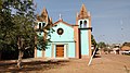 Catedral de Nossa Senhora da Graça church, Downtown Bafatá
 -
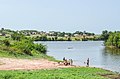 Children playing and fishing in the river
 -
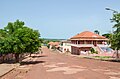
 Regional education administration building of Bafatá


.jpg)


.jpg)

References
- ^ Chabal, Patrick (2002). Amilcar Cabral: Revolutionary Leadership and People's War. C. Hurst & Co. Publishers. p. 29. ISBN 978-1-85065-548-0.
- ^ World Gazetteer[ dead link], Retrieved on June 16, 2008
- ^ Mendy, Peter Karibe (17 October 2013). Historical Dictionary of the Republic of Guinea-Bissau. Scarecrow Press. p. 92. ISBN 978-0-8108-8027-6.
- ^ Country Profile: Senegal, The Gambia, Guinea-Bissau, Cape Verde. The Unit. 1987.
- ^ Miller, Joseph C.; Havik, Philip J.; Birmingham, David (15 November 2011). A Scholar for All Seasons: Jill Dias: Portuguese Studies Review, Vol. 19, Nos. 1 and 2 (Special Volume in Memory of Jill Dias, 1944-2008) (ISSN 1057-1515). Baywolf Press. p. 216.
- ^ Official Records of the ... Session of the General Assembly: Supplement. UN. 1947.
- ^ La mortalité maternelle dans la région de Bafatá (in French). The Département. 1989.
- ^ Trillo, Richard (2 June 2008). The Rough Guide to West Africa. Rough Guides Limited. p. 1298. ISBN 978-1-4053-8068-3.
- ^ Ham, Anthony (2009). West Africa. Lonely Planet. p. 447. ISBN 978-1-74104-821-6.
- ^ "World Meteorological Organization Climate Normals for 1991-2020 — Bafatá". National Oceanic and Atmospheric Administration. Retrieved January 4, 2024.
|
| This Guinea-Bissau location article is a stub. You can help Wikipedia by expanding it. |
Bafatá | |
|---|---|
|
| |
Bafatá Location in Guinea-Bissau Bafatá Bafatá (Africa) | |
| Coordinates: 12°10′19″N 14°39′27″W / 12.17194°N 14.65750°W | |
| Country |
|
| Admin. Region | Bafatá Region |
| Elevation | 10 m (30 ft) |
| Population (2010) | |
| • Total | 34,760 |
Bafatá is a town in central Guinea-Bissau, known as the birthplace of Amílcar Cabral. [1] The town has a population of 22,501 (2008 est). [2] It is the capital of Bafatá Region as well as the seat of the Roman Catholic Diocese of Bafatá, which was established in March 2001 with Carlos Pedro Zilli as bishop. [3]
Bafatá is noted for its brickmaking. [4] By the 1880s it was an established trading centre for the Portuguese, including peanuts, cattle, hides, textiles, and salt. [5]
Landmarks
The town is served by Bafatá Airport, an airstrip, [6] and a regional hospital. [7] There is a hotel, the Bafatá Apartamento Imel. The restaurant Ponto de Encontro serves Portuguese cuisine. The surrounding forests are noted for their monkey and antelope populations, and Maimama Cape, owned by a Cape Verdean, organizes trips to visit the animals for tourists. [8] The town is in a derelict state; the streets contain tumbleweeds and cracked tarmac. [9] Several of the main avenues are named Bissau, Brazil and Guiana.
Climate
Bafatá has a tropical savanna climate ( Köppen Aw), not dissimilar to Bissau although about a third drier overall and substantially hotter during the afternoons due to its inland location. As with all of Guinea-Bissau, there are two extremely contrasting seasons: a dry season from November to May with dusty harmattan winds and sweltering, rainless weather, and a monsoonal wet season from June to October featuring heavy thunderstorm rains almost every day and hot, uncomfortably humid conditions.
| Climate data for Bafatá (1991–2020) | |||||||||||||
|---|---|---|---|---|---|---|---|---|---|---|---|---|---|
| Month | Jan | Feb | Mar | Apr | May | Jun | Jul | Aug | Sep | Oct | Nov | Dec | Year |
| Mean daily maximum °C (°F) | 34.2 (93.6) |
37.4 (99.3) |
39.0 (102.2) |
39.7 (103.5) |
38.5 (101.3) |
35.2 (95.4) |
31.9 (89.4) |
31.3 (88.3) |
31.8 (89.2) |
33.0 (91.4) |
33.9 (93.0) |
33.5 (92.3) |
35.0 (95.0) |
| Daily mean °C (°F) | 25.4 (77.7) |
27.7 (81.9) |
29.9 (85.8) |
30.8 (87.4) |
30.7 (87.3) |
28.9 (84.0) |
27.2 (81.0) |
26.7 (80.1) |
26.7 (80.1) |
27.4 (81.3) |
27.4 (81.3) |
25.0 (77.0) |
27.8 (82.0) |
| Mean daily minimum °C (°F) | 16.4 (61.5) |
17.9 (64.2) |
20.8 (69.4) |
21.9 (71.4) |
22.9 (73.2) |
22.7 (72.9) |
22.5 (72.5) |
22.1 (71.8) |
21.7 (71.1) |
21.8 (71.2) |
20.8 (69.4) |
16.4 (61.5) |
20.7 (69.3) |
| Average rainfall mm (inches) | 0.2 (0.01) |
0.0 (0.0) |
0.1 (0.00) |
0.2 (0.01) |
24.8 (0.98) |
128.9 (5.07) |
267.8 (10.54) |
344.7 (13.57) |
349.2 (13.75) |
152.4 (6.00) |
3.2 (0.13) |
0.1 (0.00) |
1,271.6 (50.06) |
| Average rainy days (≥ 1.0 mm) | 0.0 | 0.0 | 0.0 | 0.0 | 2.9 | 9.2 | 16.6 | 23.2 | 26.6 | 10.3 | 1.0 | 0.0 | 89.8 |
| Source: NOAA [10] | |||||||||||||
Gallery
-
Bafatá market
-
Bafatá, Guinea-Bissau
-
Bafatá, GBW
-
A residential street in Bafatá
-
Catedral de Nossa Senhora da Graça church, Downtown Bafatá
-
Children playing and fishing in the river
-
Regional education administration building of Bafatá
References
- ^ Chabal, Patrick (2002). Amilcar Cabral: Revolutionary Leadership and People's War. C. Hurst & Co. Publishers. p. 29. ISBN 978-1-85065-548-0.
- ^ World Gazetteer[ dead link], Retrieved on June 16, 2008
- ^ Mendy, Peter Karibe (17 October 2013). Historical Dictionary of the Republic of Guinea-Bissau. Scarecrow Press. p. 92. ISBN 978-0-8108-8027-6.
- ^ Country Profile: Senegal, The Gambia, Guinea-Bissau, Cape Verde. The Unit. 1987.
- ^ Miller, Joseph C.; Havik, Philip J.; Birmingham, David (15 November 2011). A Scholar for All Seasons: Jill Dias: Portuguese Studies Review, Vol. 19, Nos. 1 and 2 (Special Volume in Memory of Jill Dias, 1944-2008) (ISSN 1057-1515). Baywolf Press. p. 216.
- ^ Official Records of the ... Session of the General Assembly: Supplement. UN. 1947.
- ^ La mortalité maternelle dans la région de Bafatá (in French). The Département. 1989.
- ^ Trillo, Richard (2 June 2008). The Rough Guide to West Africa. Rough Guides Limited. p. 1298. ISBN 978-1-4053-8068-3.
- ^ Ham, Anthony (2009). West Africa. Lonely Planet. p. 447. ISBN 978-1-74104-821-6.
- ^ "World Meteorological Organization Climate Normals for 1991-2020 — Bafatá". National Oceanic and Atmospheric Administration. Retrieved January 4, 2024.
|
| This Guinea-Bissau location article is a stub. You can help Wikipedia by expanding it. |